I have a memory of being taken as a child to see the Windsor Ruins and I remember standing in the midst of the columns and wondering what the house looked like before it was destroyed. I also remembering being told that the fire that burned down the house was perhaps caused by someone tossing a cigarette into a wastebasket. I have no idea if the wastebasket story is true, but perhaps by the end of this post, we’ll have better idea of the truth.
The fact is, not matter what the truth is, when you stand in the middle of Windsor Ruins, you cannot help but feel the ghosts of history swirl around you. I suspect that when you stand in the ruins of a Scottish castle, the feeling would be very similar. The brain automatically tries to fill in the missing bits of the house but the proportions are immense and overwhelm the senses.
So, what is the story of the Windsor Ruins?
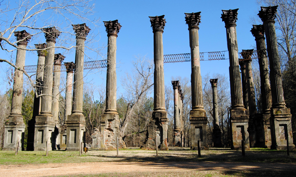
Photo by Jim Albritton
Windsor Ruins are in Claiborne County in the U.S. state of Mississippi, about 10 miles (16 km) southwest of Port Gibson near Alcorn State University. The ruins consist of 23 standing Corinthian columns of the largest antebellum Greek Revival mansion ever built in the state. The mansion stood from 1861 to 1890, when it was destroyed by fire. The 2.1-acre (0.85 ha) site was added to the National Register of Historic Places in 1971 and was designated a Mississippi Landmark in 1985.
Windsor mansion was located on a plantation that covered 2,600 acres (1,100 ha). The mansion was constructed between 1859 and 1861 for Smith Coffee Daniell II, who was born in Mississippi and had acquired great wealth as a cotton planter by age 30. In 1849, Smith Daniell married his cousin Catherine Freeland (1830–1903). The couple had six children, with three surviving to adulthood.
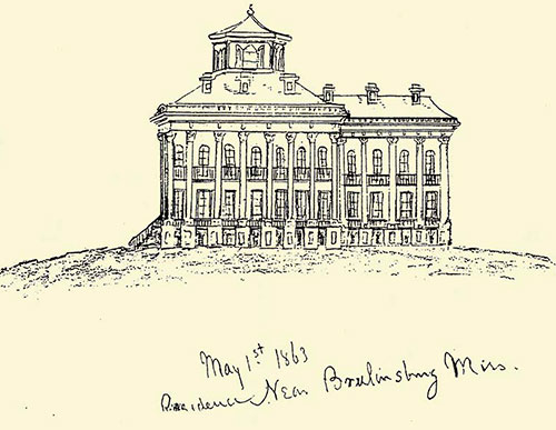
Windsor mansion was built facing the Mississippi River and was located about 4 mi (6.4 km) east of the river. Windsor mansion was constructed as a 3-story block, consisting of a ground floor basement, with living quarters on the second and third floors. The main block was 64 ft (20 m) on each side. A 3-story ell projected from the east side of the main block. The ell measured 59 ft (18 m) by 26.5 ft (8.1 m). Archeological examination suggests that outer walls were constructed of wood covered in stucco. When completed, the 17,000 sq ft (1,600 m2) mansion contained three hallways and 23 to 25 rooms, each with its own fireplace. A featured innovation for that time period was the inclusion of two interior bathrooms supplied with rainwater from a tank in the attic. In 1861, cost of construction was about $175,000 (equal to $4,593,426 today).
The ground floor basement contained a school room, doctor’s office, dairy, commissary, and storage rooms. The second floor had a hallway flanked by the master bedroom, a bathroom, two parlors, a study and a library. In the ell off the second floor was the dining room. Connected to the dining room by a dumbwaiter was the kitchen, located on the ground floor. The third floor contained an additional bath and eight more bedrooms. Eight chimneys extended from the slate-covered roof, and a domed cupola with glass walls was constructed above the attic, over the main block of the mansion.
On April 28, 1861, Smith Daniell died at age 34, just weeks after construction of the mansion was completed. Once the American Civil War began in 1861, Confederate forces used the Windsor mansion cupola as an observation platform and signal station. In the spring of 1863, as part of his Vicksburg campaign, Ulysses S. Grant and 17,000 Union troops landed at the port of Bruinsburg and took control of Windsor mansion. Following the Battle of Port Gibson, the mansion was used by Union troops as a hospital and as an observation station. The Daniell family was allowed to live on the third floor of the mansion during the Union occupation. Windsor mansion survived the war and continued to be used by the Daniell family as a home and for social gatherings in the area. During Reconstruction, the family derived income by leasing part of their vast land holdings.
On February 17, 1890, a fire started on the third floor when, according to tradition, a guest dropped ashes from a cigarette or cigar into construction debris left by carpenters who were making repairs. Windsor mansion was destroyed leaving only the columns, balustrades, cast iron stairways, and pieces of bone china.
When Catherine Daniell died in 1903, her daughter, Priscilla Daniell, inherited the mansion property. Priscilla married Joseph Magruder, and the mansion site remained in the Magruder family until 1974, when they donated 2.1 acres (0.85 ha), containing the mansion ruins, to the state of Mississippi. The historic site contains 23 standing columns and 5 partial columns; it is administered by the Mississippi Department of Archives and History.
Through the years, three of the cast iron stairways, that survived the 1890 fire, disappeared from the site. The fourth stairway was moved to Alcorn State University and serves as the entrance to Oakland Memorial Chapel.


Eva Marie Saint as Nell Gaither, Monty Clift as John Shawnessy, and Liz Taylor as Susanna Drake the 1957 M-G-M movie, Raintree County. Image courtesy of Turner Entertainment Co., A Warner Bros. Entertainment Company
The Windsor Ruins have captured the imagination of millions of visitors over the past hundred years and one great description of one person’s visit can be found at Southern Lagniappe. Janie describes her time at the ruins in great detail with a good history and some great photos. I highly recommend you check out her review.

Hubert Creekmore, Eudora, and Eileen McGrath in 1954 enjoying a picnic on grounds of Windsor Ruins in Mississippi – Photo from The Eudora Welty Foundation


 Thalia Mara died at the age of 92 in October, 2003.