When I was in the eighth grade, I was required to take two classes that were both one semester long. The first was a Civics class that was focused on teaching the basics of U.S. Citizenship and how the United States worked. The second semester, the class changed its focus to the State Of Mississippi. We learned about our state legislature, the local governance, and Mississippi history. It was one of my first formal exposures to my responsibilities as a citizen and the pride of being a resident of the Great State Of Mississippi.
I’m not sure if schools still teach Civics or State classes like that, but if not, then it is a sad thing because if kids do not learn the things to be proud about in their Country and their State, then how can they be expected to have enough pride in where they live to try and make it better. That’s one of the underlying reasons for the MadeInMississippi.us website in the first place. I wanted to build a website where people could come and browse for hours and learn about the greatness of Mississippi.
Ok, I’ll get off my soapbox now.
Anyway, when I was in my State Civics class, one of the first things we had to do was memorize the names of all eighty-two counties and then recite them back to the class. I’m not sure if the memorization had any impact on my understanding of the state, but I can tell you for certain that it made me more aware of the wide variety of lifestyles that occur naturally within the arbitrary political lines that separate us.
From the deep gullies of Adams County to the flat, alluvial plain of Sunflower County to the gulf shores of Harrison County to the low hills of Lauderdale County; the land itself influences the people who live there in ways that we can scarcely imagine. Generations of writers from William Faulkner to Eudora Welty to Willie Morris to John Grisham to Greg Iles have all spent thousands of words and pages trying to explain the impact of this soil on its people.
There’s no way I can convey in this short article the depth of the roots of the people who are born and raised here. Nor can I explain any part of what I’m trying to describe. People who were born and raised here know instinctively what I’m trying to say, but words are such fickle things they come in floods and yet still fail to adequately convey my meaning.
The best possible reaction to this post would be for people to post their feelings or descriptions of the county they were born and raised in below in the comment section and then we could all work together to give a more complete picture of the life, the land and the people that live in eighty-two separate counties that collectively make up the Great State Of Mississippi.
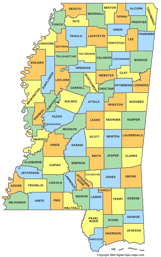
Here’s the full list of all the State Counties (click here to learn more):
| County | County seat | Established | Population | Area |
|---|---|---|---|---|
| Adams County | Natchez | 1799 | 32,297 | 460 sq mi |
| Alcorn County | Corinth | 1870 | 37,057 | 400 sq mi |
| Amite County | Liberty | 1809 | 13,131 | 730 sq mi |
| Attala County | Kosciusko | 1833 | 19,564 | 735 sq mi |
| Benton County | Ashland | 1870 | 8,729 | 407 sq mi |
| Bolivar County | Cleveland and Rosedale | 1836 | 34,145 | 876 sq mi |
| Calhoun County | Pittsboro | 1852 | 14,962 | 587 sq mi |
| Carroll County | Carrollton and Vaiden | 1833 | 10,597 | 628 sq mi |
| Chickasaw County | Houston and Okolona | 1836 | 17,392 | 502 sq mi |
| Choctaw County | Ackerman | 1833 | 8,547 | 419 sq mi |
| Claiborne County | Port Gibson | 1802 | 9,604 | 487 sq mi |
| Clarke County | Quitman | 1833 | 16,732 | 691 sq mi |
| Clay County | West Point | 1871 | 20,634 | 409 sq mi |
| Coahoma County | Clarksdale | 1836 | 26,151 | 554 sq mi |
| Copiah County | Hazlehurst | 1823 | 29,449 | 777 sq mi |
| Covington County | Collins | 1819 | 19,568 | 414 sq mi |
| DeSoto County | Hernando | 1836 | 161,252 | 478 sq mi |
| Forrest County | Hattiesburg | 1906 | 74,934 | 467 sq mi |
| Franklin County | Meadville | 1809 | 8,118 | 565 sq mi |
| George County | Lucedale | 1910 | 22,578 | 478 sq mi |
| Greene County | Leakesville | 1811 | 14,400 | 713 sq mi |
| Grenada County | Grenada | 1870 | 21,906 | 422 sq mi |
| Hancock County | Bay Saint Louis | 1812 | 43,929 | 477 sq mi |
| Harrison County | Gulfport and Biloxi | 1841 | 187,105 | 581 sq mi |
| Hinds County | Jackson and Raymond | 1821 | 245,285 | 869 sq mi |
| Holmes County | Lexington | 1833 | 19,198 | 756 sq mi |
| Humphreys County | Belzoni | 1918 | 9,375 | 418 sq mi |
| Issaquena County | Mayersville | 1844 | 1,406 | 413 sq mi |
| Itawamba County | Fulton | 1836 | 23,401 | 532 sq mi |
| Jackson County | Pascagoula | 1812 | 139,668 | 727 sq mi |
| Jasper County | Bay Springs and Paulding | 1833 | 17,062 | 676 sq mi |
| Jefferson County | Fayette | 1799 | 7,726 | 519 sq mi |
| Jefferson Davis County | Prentiss | 1906 | 12,487 | 408 sq mi |
| Jones County | Laurel and Ellisville | 1826 | 67,761 | 694 sq mi |
| Kemper County | De Kalb | 1833 | 10,456 | 766 sq mi |
| Lafayette County | Oxford | 1836 | 47,351 | 631 sq mi |
| Lamar County | Purvis | 1904 | 55,658 | 497 sq mi |
| Lauderdale County | Meridian | 1833 | 80,261 | 704 sq mi |
| Lawrence County | Monticello | 1814 | 12,929 | 431 sq mi |
| Leake County | Carthage | 1833 | 23,805 | 583 sq mi |
| Lee County | Tupelo | 1866 | 82,910 | 450 sq mi |
| Leflore County | Greenwood | 1871 | 32,317 | 592 sq mi |
| Lincoln County | Brookhaven | 1870 | 34,869 | 586 sq mi |
| Lowndes County | Columbus | 1830 | 59,779 | 502 sq mi |
| Madison County | Canton | 1828 | 95,203 | 719 sq mi |
| Marion County | Columbia | 1811 | 27,088 | 542 sq mi |
| Marshall County | Holly Springs | 1836 | 37,144 | 706 sq mi |
| Monroe County | Aberdeen | 1821 | 36,989 | 764 sq mi |
| Montgomery County | Winona | 1871 | 10,925 | 407 sq mi |
| Neshoba County | Philadelphia | 1833 | 29,676 | 570 sq mi |
| Newton County | Decatur | 1836 | 21,720 | 578 sq mi |
| Noxubee County | Macon | 1833 | 11,545 | 695 sq mi |
| Oktibbeha County | Starkville | 1833 | 47,671 | 458 sq mi |
| Panola County | Batesville and Sardis | 1836 | 34,707 | 684 sq mi |
| Pearl River County | Poplarville | 1890 | 55,834 | 812 sq mi |
| Perry County | New Augusta | 1820 | 12,250 | 647 sq mi |
| Pike County | Magnolia | 1815 | 40,404 | 409 sq mi |
| Pontotoc County | Pontotoc | 1836 | 29,957 | 497 sq mi |
| Prentiss County | Booneville | 1870 | 25,276 | 415 sq mi |
| Quitman County | Marks | 1877 | 8,223 | 405 sq mi |
| Rankin County | Brandon | 1828 | 141,617 | 775 sq mi |
| Scott County | Forest | 1833 | 28,264 | 609 sq mi |
| Sharkey County | Rolling Fork | 1876 | 4,916 | 428 sq mi |
| Simpson County | Mendenhall | 1824 | 27,503 | 589 sq mi |
| Smith County | Raleigh | 1833 | 16,491 | 636 sq mi |
| Stone County | Wiggins | 1916 | 17,786 | 445 sq mi |
| Sunflower County | Indianola | 1844 | 29,450 | 694 sq mi |
| Tallahatchie County | Charleston and Sumner | 1833 | 15,378 | 644 sq mi |
| Tate County | Senatobia | 1873 | 28,886 | 404 sq mi |
| Tippah County | Ripley | 1836 | 22,232 | 458 sq mi |
| Tishomingo County | Iuka | 1836 | 19,593 | 424 sq mi |
| Tunica County | Tunica | 1836 | 10,778 | 455 sq mi |
| Union County | New Albany | 1870 | 27,134 | 416 sq mi |
| Walthall County | Tylertown | 1912 | 15,443 | 404 sq mi |
| Warren County | Vicksburg | 1809 | 48,773 | 587 sq mi |
| Washington County | Greenville | 1827 | 51,137 | 724 sq mi |
| Wayne County | Waynesboro | 1809 | 20,747 | 810 sq mi |
| Webster County | Walthall | 1874 | 10,253 | 423 sq mi |
| Wilkinson County | Woodville | 1802 | 9,878 | 677 sq mi |
| Winston County | Louisville | 1833 | 19,198 | 607 sq mi |
| Yalobusha County | Water Valley and Coffeeville | 1833 | 12,678 | 467 sq mi |
| Yazoo County | Yazoo City | 1823 | 28,065 | 920 sq mi |
Map Courtesy of Digital-Topo-Maps.com

Hello, I grew up in MS and like many of us have sort of a love hate relationship with things Mississippi. That said, I like your site a lot. Several years ago, fearing I was on the slippery slope
to dementia, I memorized the counties and county seats. Turns out my fears of decline were unfounded ( well, at least so far ). Of course, from time to time I need to reup my memorized list. Your concise list is helpful. thanks. Incidentally, I learned that, ” I know all the county seats in Mississippi” is not a very effective pick up line. Good luck.
I am helping my 8th grader complete a project for MS Studies! He had to draw a map of the state and label the counties and their seats and the date of creation. What we can’t figure out is what the colors of the counties mean. Could you help explain that? Thank you!
As far as I can tell, the colors are only used to visually distinguish each county separately. However, you may notice there is no place on the map where two counties with the same color touch. Therefore while the map colors do not necessarily represent anything, it does bring up an interesting math theorem called the “Four Color Theorem”. The Four Color Theorem, or the four color map theorem, states that no more than four colors are required to color the regions of any map so that no two adjacent regions have the same color. In this case, there are four colors used on the map: yellow, green, blue and orange. Actually, this is a very interesting topic and worth of a side study whenever you get a chance. Click To Learn More!